
REVIEW · CAPE VERDE
Fogo Island: Spectacular Vulcano HIking Experience(2829 m)
Pico do Fogo is not a viewpoint you reach by car. You earn it one steep step at a time. This guided climb takes you from Cha das Caldeiras to 2,829 meters, Cape Verde’s highest point, with a 360-degree view that can stretch toward other islands when the weather cooperates.
I like the small group size of eight and the fact that pickup and private transport are included. You also get a guide who can adjust the climbing pace to your ability, which matters on a trail that gains about 1,050 meters. The main caution is simple: this is a difficult hike, not a gentle volcano walk, and the thin air near the top can make the final section hard.
- A true summit hike: Reach Pico do Fogo, the highest mountain in Cape Verde.
- A demanding route: Walk about 9 kilometers over 5 to 6 hours, with steep ramps and roughly 1,050 meters of climbing.
- A small group setting: The tour accepts no more than eight people, allowing the guide to watch the group more closely.
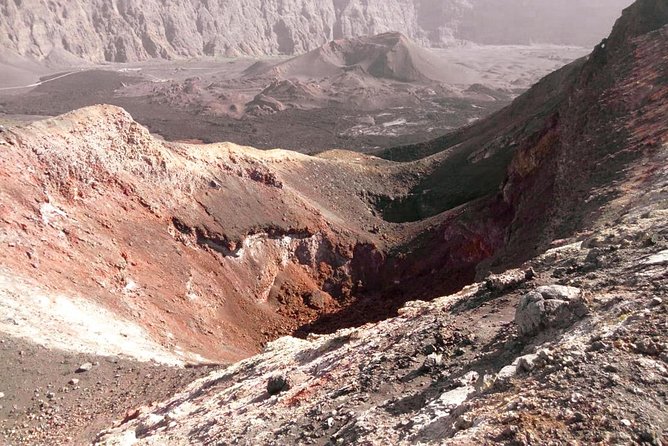
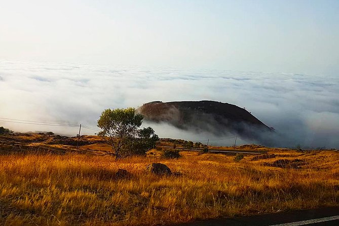
- Volcanic scenery: See the 2014 eruption area, black lava ground, the crater, and cultivated land around Fogo.
- Useful transport included: Pickup from select Fogo Island accommodations saves you from arranging a vehicle to Cha das Caldeiras.
- Strong value for active visitors: At $51.31 per person, the price covers guiding and transport for a full day in the island’s most dramatic setting.
Why Pico do Fogo Is Worth the Effort
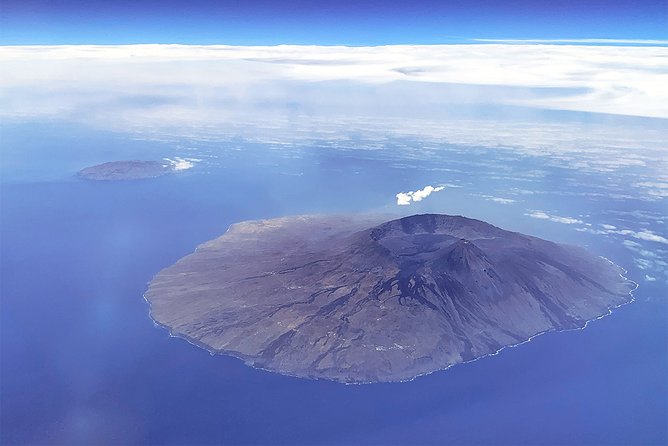
Pico do Fogo gives you the rare chance to climb an active volcanic cone in a compact, guided day trip. The mountain rises from the middle of Fogo Island, and the route takes you from the broad volcanic basin at Cha das Caldeiras to a summit high above the island.
The height is impressive, but the changing ground is what makes the climb memorable. You begin among the dark volcanic slopes and then work upward over a trail that grows steeper and narrower. Near the summit, the view opens across Fogo Island. On a clear day, you may also see other Cape Verde islands.
The volcano last erupted in 2014. That recent activity gives the setting a raw, unsettled feel. You are not walking through a polished nature park with railings and signs at every turn. This is a mountain environment shaped by lava, ash, weather, and farming.
That lack of polish is part of the appeal. It also means you should take the practical details seriously. Good hiking shoes, enough water, sun protection, and a realistic view of your fitness will make a major difference.
Pickup From Fogo Island to Cha das Caldeiras
The day begins with pickup at your accommodation in Fogo, followed by transport toward the volcano. This is one of the tour’s most useful features. You do not need to arrange a car, find the trailhead, or work out how to get back after several hours on your feet.
Pickup is offered from select locations on Fogo Island. Airport pickup can also be added for an extra fee, but it is not part of the basic price. If you need that option, check the cost and timing before booking.
The route first reaches Cha das Caldeiras, the volcanic basin at the foot of Pico do Fogo. You get about 30 minutes here to take in the mountain and the broad setting before the hard work begins.
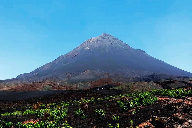
This stop is more than a waiting point. It gives you a clear sense of scale. From below, the cone looks imposing, and the path ahead makes it clear that the summit will require steady effort. The area also shows the contrast between Fogo’s black volcanic ground and the fertile soil used for green crops around the caldera.
A few more hikes around Cape Verde worth a look
- Fogo Island: Pico do Fogo Volcano Summit Hike
★ 4.6 · 92 reviews - Serra Malagueta: Principal Valley Hike & Lunch with Locals
★ 4.7 · 64 reviews - Praia: Baobab Mysterious Tree, Green Valley & Old City Hike
★ 4.8 · 53 reviews
Cha das Caldeiras and the 2014 Eruption
Cha das Caldeiras is the first place where the volcano feels fully present. The cone rises above the basin, regular in shape but far from tame. The most recent eruption took place in 2014, so the setting carries a strong sense of recent geological change.
You can expect dark lava ground and broad views around the foot of the mountain. In places, the soil supports surprisingly productive farming. That contrast is one of Fogo’s most interesting details: volcanic destruction and fertile cultivation sit close together.
The 30-minute stop gives you time for photographs and a chance to adjust your gear. Use it well. Check your shoelaces, apply sunscreen, drink water, and keep your picnic accessible. Once the ascent begins, you will want to settle into a steady rhythm rather than stop constantly to reorganize your bag.
There is no admission fee listed for this stop or for the summit hike. The value here comes from the guide, transport, and time spent on the mountain rather than from an entrance ticket.
The Four-Hour Ascent to 2,829 Meters
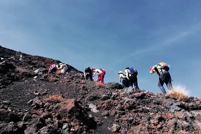
The main climb takes about four hours. The guide adjusts the pace to match the group’s ability, which is important because the route is described as difficult, with steep ramps and a narrow but safe path.
The total walk is about 9 kilometers. That distance may not sound huge on paper, but distance alone does not tell the story. You gain about 1,050 meters, then lose roughly the same amount on the way back. Much of the effort comes from the incline, the volcanic footing, and the sustained time on your legs.
You should plan to walk slowly and keep your energy in reserve. A fast start can make the upper section much harder. The guide’s role is valuable here. Rather than treating the climb as a race, the pace can be adjusted so you have a better chance of reaching the top without exhausting yourself too early.
The trail is described as narrow in places, but safe. That does not mean easy. Wear hiking shoes with good grip, not casual sneakers. Walking sticks are also recommended, especially for the descent when tired legs and loose volcanic ground can make each step less certain.
At the summit, you reach the highest point in Cape Verde. Pico do Fogo is also described as the third-highest mountain in the Atlantic Ocean. The reward is a wide view over Fogo Island, with the possibility of seeing other islands in clear weather.
Weather will shape the summit experience. Cloud, wind, or haze may limit the view, so do not judge the hike only by the promise of a perfect panorama. The climb remains worthwhile for the volcanic setting and the sense of reaching the island’s highest point.
A Walk Through the Crater
After reaching the summit, the route continues with a walk through the crater. This adds another layer to the experience. You are not simply climbing to a marked high point, taking one photograph, and turning around.
The crater lets you see the volcanic structure from close range. The ground around the cone is described as deep black, with lava-covered sections and signs of fertile growth farther across Fogo. It is a sharp visual change from the cultivated areas near the caldera.
The summit section is also where the height becomes most noticeable. At about 2,830 meters, you may feel the effort of the ascent more than you did at the start. Keep your pace controlled, drink water, and listen to the guide’s instructions.
One especially memorable version of this outing includes arriving at the volcano in darkness and watching sunrise inside the crater. The exact timing is not stated as part of every departure, so ask the operator before booking if a pre-dawn start is important to you. If offered, that timing would add another strong reason to carry a warm layer and headlamp-ready equipment, though those items are not specifically listed among the required supplies.
Same trailhead, a different sort of day:
- Santiago: Monte Tchota Natural Park to Pico d’Antónia Hike
★ 4.8 · 43 reviews - From Tarrafal: Serra to Principal Hike & Lunch with locals
★ 4.7 · 41 reviews - Santa Maria: Guided Coastal Hike & Monte Leão Sunset
★ 4.5 · 37 reviews - Santo Antão: Hiking Cova Volcano Crater to Ribeira Paúl
★ 4.5 · 31 reviews
The Descent Back to Fogo
The return walk takes you back toward your accommodation in Fogo and forms the closing part of a day of about seven hours. The schedule allows roughly 30 minutes for the final return portion, while the full walking time is given as 5 to 6 hours.
The descent is not an afterthought. It can be hard on knees and ankles, particularly after the climb and crater walk. Walking sticks can help, and careful foot placement matters on steep or uneven ground.
This is another reason I prefer the guided format over attempting the route alone. The guide can help set a sensible pace, keep the group together, and make practical calls as weather and energy levels change. The tour description notes that some intrepid people drive themselves to Pico do Fogo and climb without a guide, but most people will find the support worth the cost.
The small group limit helps here. With no more than eight people, the outing should feel more manageable than a large coach group spread along a mountain path. It also gives the guide a better chance to notice when someone needs a slower pace or a short break.
What the $51.31 Price Really Covers
At $51.31 per person, this is a strong price for a full-day mountain activity if you are already staying on Fogo Island. The fee includes the guided hike and private transportation, two costs that can be inconvenient to arrange separately.
You are paying for more than a ride to a trailhead. You get help with route finding, pacing, and the practical demands of a difficult ascent. The guide also adds context to the volcanic setting and can help you make better decisions during the climb.
The value is strongest for visitors without their own transport, anyone who prefers not to manage an unfamiliar mountain route alone, and people who want a small group rather than a large excursion. If you are a strong hiker with your own vehicle and plenty of experience on volcanic terrain, you may decide to go independently. Even then, the guide can be a sensible investment for comfort and safety.
The airport pickup option costs extra, so factor that in if you are planning to connect the hike directly with an arrival. The standard price does not cover food or drinks, so bring your own picnic and water.
Fitness, Equipment, and Honest Difficulty
This hike requires a strong level of physical fitness. The difficulty rating is not decorative. You will walk 5 to 6 hours, climb about 1,050 meters, reach roughly 2,830 meters, and then descend the same general amount.
Bring:
- Hiking shoes
- Walking sticks
- A hat
- Sunscreen
- A picnic
- Plenty of water
The supplied advice does not give an exact water quantity, so you should plan carefully rather than assume refreshments will be available on the route. Food is also your responsibility. A picnic that is easy to eat during a break makes more sense than anything heavy or complicated.
Dress for changing conditions, but do not rely on unlisted equipment being provided. The information specifically asks you to bring the items above. You should also check the forecast and confirm the meeting time before the day of the climb.
The biggest mistake would be treating this as a sightseeing outing with a short stroll. It is an athletic day in a high volcanic setting. If you already enjoy long uphill walks, you may find the challenge satisfying. If you rarely hike or dislike steep climbs, this is probably the wrong Fogo activity.
The Warm Human Side of the Day
The mountain is the main attraction, but the tone of the outing matters too. The local guiding team is described as friendly and generous with information, and the welcome during lunch is warm and informal.
That detail is worth noting because a demanding hike can feel much better when the people around you are encouraging and easy to talk with. The experience is not only about reaching 2,829 meters. It also gives you time with a local team who can share the place from a closer, more personal angle.
Still, I would keep expectations realistic. The included information does not name the guides, and it does not promise a specific lunch or meal service. Bring your own picnic as instructed rather than assuming lunch is supplied.
The strongest praise centers on the atmosphere at the volcano, the guide support, and the warm welcome around the meal break. Those are good signs for anyone who values human contact along with scenery, but your main reason for booking should remain the hike itself.
Who Should Book This Volcano Hike?
I would recommend this tour to you if you want Fogo’s biggest physical challenge and prefer not to organize transport or route-finding yourself. It suits active visitors who can handle a long, steep day and who appreciate a guide setting the pace.
It is also a good match if you are visiting Fogo for a short time. A seven-hour outing covers the island’s major volcanic setting in one focused day, leaving little planning for you beyond packing the right gear.
I would hesitate to recommend it if you have limited fitness, trouble with steep trails, or no interest in spending most of a day walking uphill and downhill. A high summit and impressive photographs do not make the physical demands disappear.
The small group limit, private transport, and modest price make the guided option appealing. Just be honest with yourself about the difficulty before you reserve it.
Final Verdict: Book It If You Want Fogo on Foot
Book this tour if reaching Cape Verde’s highest point matters to you and you are ready for a difficult 5 to 6-hour walk. The guide, pickup service, small group, crater walk, and summit views give the $51.31 price solid value.
Skip it if you want a relaxed volcano visit or if a 1,050-meter climb sounds excessive. For fit hikers, though, this is one of the clearest ways to experience Fogo: not from a roadside viewpoint, but from the black volcanic slopes and the summit itself.
FAQ
How long does the Pico do Fogo tour last?
The full experience lasts about seven hours. Total walking time is approximately 5 to 6 hours.
How far is the hiking route?
The walking distance is about 9 kilometers. The trail is a loop with both an ascent and a descent.
How high does the hike go?
The summit reaches about 2,829 meters. Pico do Fogo is the highest mountain in Cape Verde.
Is pickup included?
Pickup is offered from select accommodations on Fogo Island, and private transportation is included. Airport pickup is available for an additional fee.
What should I bring?
Bring hiking shoes, walking sticks, a hat, sunscreen, a picnic, and water. The activity requires a strong level of physical fitness.
How many people are in the group?
The tour has a maximum of eight participants.
Just added around Cape Verde
- Tarrafal: From Praia:Hike in Serra Malagueta Natural Park★ 4.2 · 6 reviews
- Santo Antão: Ponta do Sol & Fontainhas Guided Trip with Hike★ 4.8 · 9 reviews
- Santo Antão: Hiking Cova Volcano Crater to Ribeira Paúl★ 4.5 · 31 reviews
- Santa Maria: Guided Coastal Hike & Monte Leão Sunset★ 4.5 · 37 reviews
- Ribeira Grande: Hiking Day Trip to Ribeira de Torre★ 4.9 · 4 reviews
- Private Hike through mountains and distant rural villages★ 5.0 · 8 reviews
- Paúl hike, the green garden★ 4.5 · 4 reviews
- Hike Volcano Viana★ 5.0 · 3 reviews
Cape Verde Hiking Tours, compared.

Serra Malagueta: Principal Valley Hike & Lunch with Locals
Read our review →
Praia: Baobab Mysterious Tree, Green Valley & Old City Hike
Read our review →
Santiago: Monte Tchota Natural Park to Pico d’Antónia Hike
Read our review →
From Tarrafal: Serra to Principal Hike & Lunch with locals
Read our review →
Santa Maria: Guided Coastal Hike & Monte Leão Sunset
Read our review →
Santo Antão: Hiking Cova Volcano Crater to Ribeira Paúl
Read our review →
Serra Malagueta Natural Park: Hike to Gongon Valley & Lunch
Read our review →Browse the lists this tour appears in